Friday, March 13, 2009
Jerusalem
When I was in Israel last March, I had a little time off from work -- three days during a two-week period to be exact. Knowing that I may not make it back to Israel for a while, I made full use of my time off and went on every excursion that the embassy put together for us. The tours weren’t free, but the embassy coordinated the tour guide and bus company and left it up to us to decide whether we wanted to participate. You betcha I did!
Our first excursion was to Jerusalem. There is sooo much to see in the Holy City, and we tried to fit in a lot. Granted, we only had one day in Jerusalem and there were a few places we couldn’t go while on a U.S. embassy-coordinated tour, such as the Dome of the Rock and nearby Bethlehem, but I still marveled at everything we did experience.
 On the drive from Tel Aviv to Jerusalem, we saw many settlements dotting the landscape. Our tour guide explained that Jewish neighborhoods (size-wise, akin to villages and small towns) on the outskirts of Jerusalem are officially considered part of Jerusalem in order to keep the official Jewish population of Jerusalem in balance with the Muslim population. Some of these neighborhoods were easily 15 to 20 minutes outside of Jerusalem proper. In other parts of the country, these distinct neighborhoods are separate from the nearby city.
 Our first stop was to Mount Scopus for a view toward the west overlooking the city. If you look closely at the left of the skyline, you can make out the gold dome of the Dome of the Rock. I’ve included several other, closer, photos of this site -- one of the most visible sites on the city’s skyline.
 Our next stop was a little farther south, overlooking the Mount Scopus Forest to the east. It was a slightly hazy day, and my camera lens needed cleaning, but off in the distance are the hills of Jordan. This desert is where King David ran away to (there will be another post on Ein Gedi), as well as the area of the Jordan River where John the Baptist cleansed people and baptized Jesus. If you look at the road in the foreground, you can see a fence just behind it. This is part of the project to fence in all Jewish settlements. It’s quite a project since Jewish and Muslim settlements are so interspersed -- from here, a Muslim neighborhood is in the foreground while a Jewish neighborhood is further away.
 Form there, we traveled to the Mount of Olives and walked beside the most important Jewish cemetery in Jerusalem. The tradition of placing stones on Jewish graves originated here. Since this cemetery is on a hillside, the graves would become uncovered over time, so passersby would place stones on the gravesites to keep the graves covered. The holes on the ends of the tombs are for visitors to light candles on the anniversary of the person’s death, and the candles are to remain lit for 24 hours.
 Legend has it that on judgment day, the Messiah will enter the Temple Courts through the blocked Golden Gate just across the valley, so pious Jews chose to be buried here so they will be nearby on the Day of Redemption. There are an estimated 150,000 graves on the Mount of Olives, including tombs of important rabbis from the 15th to the 20th centuries. At the bottom of this staircase is a well from the City of David. You can see the Dome of the Rock from here as well.
 We passed this Bedouin and his donkey as we walked to the Roman Catholic Dominus Flevit Church. This is one of the newest churches in Jerusalem (completed in 1955), and is built on the site where, according to the 19th chapter of the Luke, Jesus openly wept after becoming overwhelmed by the beauty of the Second Temple and predicting its future destruction and the diaspora of the Jewish people.
 “And when he was come near, he beheld the city, and wept over it, saying, ... For the days shall come upon thee, that thine enemies shall cast a trench about thee, and compass thee round, and keep thee in on every side, and shall lay thee even with the ground, and thy children within thee; and they shall not leave in thee one stone upon another; because thou knewest not the time of they visitation.”
-- Luke 19: 41-44
I couldn’t get a good photo of the Dominus Flevit Church, but did like this view of Jerusalem from the church gardens. The Mount of Olives Cemetery is in the foreground, looking toward the Jewish Quarter.
 During the church’s construction, workers unearthed ancient tombs, including a late bronze-era tomb from the Canaanite period, as well as a necropolis used from 136 BC to 300 AD.
 Here’s another close-up of the Dome of the Rock. The gray-dome behind it is the Church of the Holy Sepulcher, where Jesus was crucified and buried. The Temple Mount where the Dome of the Rock sits is the historical and spiritual focus of Jerusalem. Jews revere it as the holiest place on earth since the rock at the center of the Temple Mount (now covered by the Dome of the Rock) is where Abraham prepared to sacrifice his son Isaac. Christianity associates the Temple Mount with the preaching of Jesus. Muslims accept this as the location where Mohammed ascended to heaven and returned five days later.
 I didn’t realize until later that my zoom lens was overexposing every shot I took with it, so you’ll have to excuse the quality of these next two photos. Even with the poor quality, you can make out the magnitude of the cemetery on the Mount of Olives.
 I thought it was interesting that a heard of goats meandered through the cemetery. I didn’t see anyone leading them -- just the goats making their way up the hill.
 Here’s yet another view with the Dome of the Rock, the dome of the Church of the Holy Sepulcher and the east wall of the Temple Mount behind me. The sealed Golden Gate is not visible (behind my head), but is where Jewish tradition holds that the Messiah will enter Jerusalem. The Golden Gate is also called the Gate of Mercy.
 This is a view of the cemetery on the Mount of Olives from the adjacent to Jerusalem’s east wall. The stairway that we walked down is to the far left.
 Just down from the Basilica of Gethsemane (which will have its own post) is the Church of the Tomb of the Virgin Mary. The church was built by the Crusaders and is managed today by the Armenian and Greek Orthodox churches. Inside the church are also alters dedicated to Mary’s parents, Joachim and Anne. The church was flooded in 2007, destroying many of the Russian icons inside, so it was being rebuilt when I was there.

 After visiting the Upper Last Supper Room (which will also have its own post), we drove past some protestors demonstrating against a killing in a religious school just a few days earlier. A stark reminder that peace is fragile here.
 This is a view looking south from Jerusalem. Looking at the skyline beginning at the left is King Harrods’ burial Mausoleum (it looks like a flat-peaked volcano). The fields to the right of that (just left of center) are where the shepherds saw the angel proclaim Jesus’ birth. The houses in the foreground are Muslim houses, as our tour guide regularly pointed out. Muslim houses are never quite complete since families continue adding additional stories to their homes as their sons marry and move into the next-top story of their father’s home. The white tanks on the rooftops are water tanks. If the water pipes in the houses were never completed -- closed off -- there wouldn’t be sufficient water pressure to even flush the toilets. So, these water tanks seal off the circuitry of pipes while allowing room for growth when time to add the next level above. Very interesting!
 Continuing with the skyline description, just to the right of the “white stripes” (in the left half of the photo -- I’m not sure what that area is) is Bethlehem. Yup, Jesus’ birthplace. You can see a glimpse of the white stripes in the previous photo -- on the very right edge -- to give you a perspective of how close together everything is. This is as close as we were allowed to get to Bethlehem -- it’s really not a safe place to visit (a Hamas leader was killed there while I was in Israel). More Muslim houses in the foreground.
 This is a view of Jerusalem from near where we saw Bethlehem. Beginning at the left, you can see the Old City Walls, the Western Wall, the Dome of the Rock, the Temple Mount, Mount Scopus and the Mount of Olives Cemetery.
 Continuing where the previous photo left off, this vantage point shows the Jordan Valley and the Hills of Moab (Jordan) with the Dead West Bank leading to the Dead Sea (yup, expect a separate post on that excursion) off in the distance on the right.
 We then headed back into Jerusalem and the Temple Mount. We saw the Tower of David when we entered the Old City through the Jaffa Gate.
 The Citadel is adjacent to the Jaffa Gate on the western side of the city, and stands where Herod built his palace at the end of the first century B.C. This is the only part of the city walls that remained intact after the Romans destroyed Jerusalem.
 This is the bell tower of the Lutheran Church of the Redeemer.
 We climbed to a nearby rooftop for a wonderful panorama of the city, and the Dome of the Rock with the Mount of Olives Cemetery further to the right.
 Even though my zoom lens was overexposing everything, I like this shot of the Dome of the Rock with the Russian Orthodox Church of Mary Magdalene in the background.
 The gray dome behind me is the Church of the Holy Sepulcher, marking where Jesus was crucified and buried. There will be a separate post on this church as well.
 The Jewish Quarter has been extensively excavated. This wide, colonnaded street is a part of the restored Byzantine Cardo Maximus and was once the main thoroughfare of the Roman-Byzantine city. It’s interesting how the street has been reconstructed and shops now stand on the original paving stones.
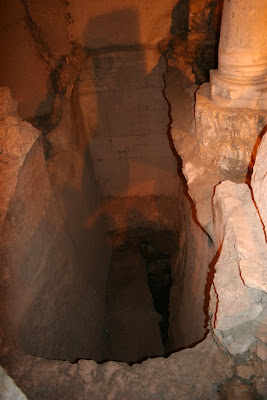 This excavation site shows how deep the city actually is -- and how its citizens continued to build upon previous structures.
 This is a 5th century street just outside the shopping area -- it used to be a Crusaders’ market.
 Our tour guide stopped to show us the 6th century Madaba mosaic map of Jerusalem that shows St. Stephen’s Gate at the top with the Temple Mount and Western Wall leading to the right, the Damascus Gate at the left and the Church of the Holy Sepulcher at the center bottom. The map was saved by accident.
 More excavations near the shopping area.
 When we finally loaded back onto the bus for our ride back to Tel Aviv, the sun was beginning to set, creating long shadows in the desert to the east of Jerusalem. If you look closely, you can see a road with fence being built just behind it as part of the project to fence in all Jewish settlements. You can also see a pyramid-looking structure on the horizon. Behind this is the Jordan River where John the Baptist baptized Jesus -- as our tour guide said, “in Kosher water.”
 You can see a little of the road and fence in the foreground on the left, and the pyramid-looking structure beyond it, also on the left. This is also the wilderness where Moses wandered for 40 years. In today’s perspective on distances, he was very close to Jerusalem yet never made it out of the desert.
Our first excursion was to Jerusalem. There is sooo much to see in the Holy City, and we tried to fit in a lot. Granted, we only had one day in Jerusalem and there were a few places we couldn’t go while on a U.S. embassy-coordinated tour, such as the Dome of the Rock and nearby Bethlehem, but I still marveled at everything we did experience.
 On the drive from Tel Aviv to Jerusalem, we saw many settlements dotting the landscape. Our tour guide explained that Jewish neighborhoods (size-wise, akin to villages and small towns) on the outskirts of Jerusalem are officially considered part of Jerusalem in order to keep the official Jewish population of Jerusalem in balance with the Muslim population. Some of these neighborhoods were easily 15 to 20 minutes outside of Jerusalem proper. In other parts of the country, these distinct neighborhoods are separate from the nearby city.
 Our first stop was to Mount Scopus for a view toward the west overlooking the city. If you look closely at the left of the skyline, you can make out the gold dome of the Dome of the Rock. I’ve included several other, closer, photos of this site -- one of the most visible sites on the city’s skyline.
 Our next stop was a little farther south, overlooking the Mount Scopus Forest to the east. It was a slightly hazy day, and my camera lens needed cleaning, but off in the distance are the hills of Jordan. This desert is where King David ran away to (there will be another post on Ein Gedi), as well as the area of the Jordan River where John the Baptist cleansed people and baptized Jesus. If you look at the road in the foreground, you can see a fence just behind it. This is part of the project to fence in all Jewish settlements. It’s quite a project since Jewish and Muslim settlements are so interspersed -- from here, a Muslim neighborhood is in the foreground while a Jewish neighborhood is further away.
 Form there, we traveled to the Mount of Olives and walked beside the most important Jewish cemetery in Jerusalem. The tradition of placing stones on Jewish graves originated here. Since this cemetery is on a hillside, the graves would become uncovered over time, so passersby would place stones on the gravesites to keep the graves covered. The holes on the ends of the tombs are for visitors to light candles on the anniversary of the person’s death, and the candles are to remain lit for 24 hours.
 Legend has it that on judgment day, the Messiah will enter the Temple Courts through the blocked Golden Gate just across the valley, so pious Jews chose to be buried here so they will be nearby on the Day of Redemption. There are an estimated 150,000 graves on the Mount of Olives, including tombs of important rabbis from the 15th to the 20th centuries. At the bottom of this staircase is a well from the City of David. You can see the Dome of the Rock from here as well.
 We passed this Bedouin and his donkey as we walked to the Roman Catholic Dominus Flevit Church. This is one of the newest churches in Jerusalem (completed in 1955), and is built on the site where, according to the 19th chapter of the Luke, Jesus openly wept after becoming overwhelmed by the beauty of the Second Temple and predicting its future destruction and the diaspora of the Jewish people.
 “And when he was come near, he beheld the city, and wept over it, saying, ... For the days shall come upon thee, that thine enemies shall cast a trench about thee, and compass thee round, and keep thee in on every side, and shall lay thee even with the ground, and thy children within thee; and they shall not leave in thee one stone upon another; because thou knewest not the time of they visitation.”
-- Luke 19: 41-44
I couldn’t get a good photo of the Dominus Flevit Church, but did like this view of Jerusalem from the church gardens. The Mount of Olives Cemetery is in the foreground, looking toward the Jewish Quarter.
 During the church’s construction, workers unearthed ancient tombs, including a late bronze-era tomb from the Canaanite period, as well as a necropolis used from 136 BC to 300 AD.
 Here’s another close-up of the Dome of the Rock. The gray-dome behind it is the Church of the Holy Sepulcher, where Jesus was crucified and buried. The Temple Mount where the Dome of the Rock sits is the historical and spiritual focus of Jerusalem. Jews revere it as the holiest place on earth since the rock at the center of the Temple Mount (now covered by the Dome of the Rock) is where Abraham prepared to sacrifice his son Isaac. Christianity associates the Temple Mount with the preaching of Jesus. Muslims accept this as the location where Mohammed ascended to heaven and returned five days later.
 I didn’t realize until later that my zoom lens was overexposing every shot I took with it, so you’ll have to excuse the quality of these next two photos. Even with the poor quality, you can make out the magnitude of the cemetery on the Mount of Olives.
 I thought it was interesting that a heard of goats meandered through the cemetery. I didn’t see anyone leading them -- just the goats making their way up the hill.
 Here’s yet another view with the Dome of the Rock, the dome of the Church of the Holy Sepulcher and the east wall of the Temple Mount behind me. The sealed Golden Gate is not visible (behind my head), but is where Jewish tradition holds that the Messiah will enter Jerusalem. The Golden Gate is also called the Gate of Mercy.
 This is a view of the cemetery on the Mount of Olives from the adjacent to Jerusalem’s east wall. The stairway that we walked down is to the far left.
 Just down from the Basilica of Gethsemane (which will have its own post) is the Church of the Tomb of the Virgin Mary. The church was built by the Crusaders and is managed today by the Armenian and Greek Orthodox churches. Inside the church are also alters dedicated to Mary’s parents, Joachim and Anne. The church was flooded in 2007, destroying many of the Russian icons inside, so it was being rebuilt when I was there.
 After visiting the Upper Last Supper Room (which will also have its own post), we drove past some protestors demonstrating against a killing in a religious school just a few days earlier. A stark reminder that peace is fragile here.
 This is a view looking south from Jerusalem. Looking at the skyline beginning at the left is King Harrods’ burial Mausoleum (it looks like a flat-peaked volcano). The fields to the right of that (just left of center) are where the shepherds saw the angel proclaim Jesus’ birth. The houses in the foreground are Muslim houses, as our tour guide regularly pointed out. Muslim houses are never quite complete since families continue adding additional stories to their homes as their sons marry and move into the next-top story of their father’s home. The white tanks on the rooftops are water tanks. If the water pipes in the houses were never completed -- closed off -- there wouldn’t be sufficient water pressure to even flush the toilets. So, these water tanks seal off the circuitry of pipes while allowing room for growth when time to add the next level above. Very interesting!
 Continuing with the skyline description, just to the right of the “white stripes” (in the left half of the photo -- I’m not sure what that area is) is Bethlehem. Yup, Jesus’ birthplace. You can see a glimpse of the white stripes in the previous photo -- on the very right edge -- to give you a perspective of how close together everything is. This is as close as we were allowed to get to Bethlehem -- it’s really not a safe place to visit (a Hamas leader was killed there while I was in Israel). More Muslim houses in the foreground.
 This is a view of Jerusalem from near where we saw Bethlehem. Beginning at the left, you can see the Old City Walls, the Western Wall, the Dome of the Rock, the Temple Mount, Mount Scopus and the Mount of Olives Cemetery.
 Continuing where the previous photo left off, this vantage point shows the Jordan Valley and the Hills of Moab (Jordan) with the Dead West Bank leading to the Dead Sea (yup, expect a separate post on that excursion) off in the distance on the right.
 We then headed back into Jerusalem and the Temple Mount. We saw the Tower of David when we entered the Old City through the Jaffa Gate.
 The Citadel is adjacent to the Jaffa Gate on the western side of the city, and stands where Herod built his palace at the end of the first century B.C. This is the only part of the city walls that remained intact after the Romans destroyed Jerusalem.
 This is the bell tower of the Lutheran Church of the Redeemer.
 We climbed to a nearby rooftop for a wonderful panorama of the city, and the Dome of the Rock with the Mount of Olives Cemetery further to the right.
 Even though my zoom lens was overexposing everything, I like this shot of the Dome of the Rock with the Russian Orthodox Church of Mary Magdalene in the background.
 The gray dome behind me is the Church of the Holy Sepulcher, marking where Jesus was crucified and buried. There will be a separate post on this church as well.
 The Jewish Quarter has been extensively excavated. This wide, colonnaded street is a part of the restored Byzantine Cardo Maximus and was once the main thoroughfare of the Roman-Byzantine city. It’s interesting how the street has been reconstructed and shops now stand on the original paving stones.
 This excavation site shows how deep the city actually is -- and how its citizens continued to build upon previous structures.
 This is a 5th century street just outside the shopping area -- it used to be a Crusaders’ market.
 Our tour guide stopped to show us the 6th century Madaba mosaic map of Jerusalem that shows St. Stephen’s Gate at the top with the Temple Mount and Western Wall leading to the right, the Damascus Gate at the left and the Church of the Holy Sepulcher at the center bottom. The map was saved by accident.
 More excavations near the shopping area.
 When we finally loaded back onto the bus for our ride back to Tel Aviv, the sun was beginning to set, creating long shadows in the desert to the east of Jerusalem. If you look closely, you can see a road with fence being built just behind it as part of the project to fence in all Jewish settlements. You can also see a pyramid-looking structure on the horizon. Behind this is the Jordan River where John the Baptist baptized Jesus -- as our tour guide said, “in Kosher water.”
 You can see a little of the road and fence in the foreground on the left, and the pyramid-looking structure beyond it, also on the left. This is also the wilderness where Moses wandered for 40 years. In today’s perspective on distances, he was very close to Jerusalem yet never made it out of the desert.
![]()
